Use your widget sidebars in the admin Design tab to change this little blurb here. Add the text widget to the Blurb Sidebar!
Posted: August 20th, 2002 | Author: Lori Paximadis | Filed under: cross-country adventure | Comments Off on the end of the journey, and the beginning of the next
I am here. The whole update thing fell apart a bit at the end there, but all is well 5345 miles after beginning the driving portion of this journey. I saw some truly beautiful places, and felt blessed to be able to spend a day or so with so many friends and relatives along the way.
T was upset that I didn’t go to Graceland when I was in Memphis, considering that it was the 25th anniversary of Elvis’s death and all, but really, Elvis — dead or alive — just doesn’t do it for me.
Monday the 12th was the longest driving day of all, timewise. I was curious to see the place I was born, since my family left there when I was all of 18 months old, so I planned my route to circle through a big regional park before swinging back down to my birthplace then most of the way across Kentucky. My map book deceived me again, letting me believe that it would be a mere side trip to visit the Land Between the Lakes, but it was a journey in and of itself. And at the end of it, there wasn’t much unique scenery in the park itself; it could have been any old park road winding through the trees. I didn’t even see any buffalo in the buffalo range.
The place of my birth was like any other middle-of-nowhere military town: pawn shops, fast food joints, scary-looking bars, military surplus stores, and lots of dust. Strangely like Wahiawa. Sadly, there had been some confusion as to when my arrival would be, so they had planned the parade and festival for Tuesday, and by their account I was there a day early. Not really wanting to stick around and partake in the funfest that is Oak Grove, Kentucky, I disappointed the entire town by telling them that they would have to have their Welcome Back Lori party without me, as I was pressing on to Lexington that afternoon.
The Kentucky parkway system is fantastic driving and apparently underused. It was smooth sailing the whole way with little traffic and lots of speed. If it weren’t for my forgetting about the time change in the middle of that fair state, I would have actually been early to H&W’s house. Alas. We all had a great time. W & I took a side trip to Berea, Kentucky on Tuesday. I have always wanted to go there for two reasons: (1) I spent most of my childhood in Berea, Ohio, and wanted to know what Berea, Kentucky, is like and (2) I’m an artsy-craftsy person and Berea, Kentucky, is an artsy-craftsy town, complete with artsy-craftsy shops and an artsy-craftsy college, appropriately named Berea College. I bought a few little things and had a little chat with a dulcimer maker.
Wednesday I made the switch over to E&D’s house, and had a great time there as well. We all saw My Big Fat Greek Wedding — highly recommended. E & I took a side trip to Shakertown on Thursday, where we poked around and took some pictures and then had a really good lunch. We bought a whole pie of their famous lemon variety to take home for dinner, but consensus was that it really was, well, kind of weird and not much to our collective liking. At least there was ice cream to take some of the bitter edge off.
Friday I left the fair town of Lexington, which I like very much, and headed for Cincinnati. I stayed with J and her parents, who were very welcoming despite my not having met them before. We people-watched at a trendy restaurant and a trendier bar on Friday, where I was reminded how much I never want to have to partake in the stereotypical singles scene. We had some truly excellent fish & chips at a pub in Newport, Kentucky, on Saturday and bought some Powerball tickets while we were there (didn’t win).
Sunday morning I drove through a bit of rain to Columbus, where I marveled at how much perfectly good stuff the infernal Campus Partners had knocked down in the name of “progress” around Ohio State and had a nice lunch with J (not the same J as above), before merging onto the bone-familiar stretch of I-71 that would take me home. The old joke that a friend sent me several months ago held: What are the four seasons in Ohio? Almost Winter, Winter, Still Winter, and Construction. I don’t think that there has been a single summer in my entire driving existence that there hasn’t been major construction on at least part of that stretch of 71.
I cut off onto 83 — a new move since the family has shifted west — and laughed at the alpalcas on the farms on the way up. They’re such ungainly but cute creatures. I came through the newer part of Avon Lake into the older and caught my first glimpse of the lake, and it did feel like coming home. I loved Hawaii, the climate, the beaches, and especially my friends, but this feels right to be here now. Mom was of course happy to see me, although shockingly not too teary.
The past two days have been busy with me clearing all the stuff out of my car and trying to impose some order on it, doing laundry, seeing relatives, going through my mountain of mail, getting information on banks, figuring out where the post office is, and taking a preliminary run through a few neighborhoods to see what areas I might be able to afford a house in. It should all settle down a little by next week, I hope.
Posted: August 11th, 2002 | Author: Lori Paximadis | Filed under: cross-country adventure | Comments Off on Texas to Tennessee
Had a really good time with C & MK.
I crossed the Mississippi today at Memphis, officially crossing into the land where you’re asked whether you want your iced tea “suhweet or uhnsuhweet, hon?”
Watching CNN makes me twitchy. All that crap on every inch of the screen is just ridiculous. It makes it hard to focus on anything at all.
Today was my longest drive in terms of point-to-point distance: 470 miles, from the Fort Worth area across the whole of Arkansas to Memphis. Tomorrow’s leg to Lexington will not be quite so much distance but will be almost as long timewise, as I plan to take some back roads and take a little detour through the area where I was born.
Posted: August 3rd, 2002 | Author: Lori Paximadis | Filed under: cross-country adventure | 2 Comments »
I left the San Francisco area without actually going into the city, save the drive through on 101 on the way down. The course sucked up so much time and energy — as y’all know since I managed only one quick update while there — that the one half-day off I had I spent in mindless mall wandering and getting my poor, dirty car washed.
From Stanford I headed over to Santa Cruz. I had hoped to park and take a walk on the boardwalk and grab some real breakfast, but parking was outrageous and nothing seemed to be open anyway. On the way out I cruised through downtown proper, and again nothing seemed to be open. It might be a fun place another time.
From there I drove around the bay to Monterey and Pacific Grove just beyond, and fell in love. Pacific Grove is everything you imagine a California coastal town to be, except even more expensive than you think it is. I have decided that when I have my billions, I will have a little house here. I did the obligatory 17 Mile Drive, which lives up to its hype and is worth the $8 it costs to drive it. Stopped in Carmel for some gas on the other side; would have liked to have wandered a bit, but there was not a parking spot in sight for miles around. Seems like a grand little town, though.
People had warned me about Highway 1 south of there, but I have to say that it was a piece of cake compared to the northern California section. It was twisty-turny, but mostly well-paved and wide and just a gorgeous, gorgeous road. There was more traffic than on the upper part, though.
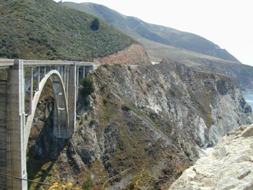
I made the stop at the famous Nepenthe for a late lunch and a refreshing beverage. The food was merely okay but grandly overpriced and the service was amazingly slow, but wow what a cool place. Its decks are perched 800-some feet above the sea below — straight below — and the views are surreal. I chatted with the couple next to me at the bar, he from LA and she recently arrived from Colombia, and realized how woefully bad my Spanish has become. I need to do something about that.
I made it to Hearst Castle in San Simeon an hour before closing, and an hour after the last tour of the day. I inquired about tours the next morning, and was told that they were already sold out until the next afternoon, so decided to give it a pass until next time. My hotel was in San Luis Obispo, about an hour farther south. San Luis Obispo is another California town that I like a lot. It has a nice downtown area with some nice cafes and coffeehouses, *two* old-style movie theaters, and a Spanish mission (where Mass was taking place, so I didn’t get to poke my head in). Being that it was Sunday evening, all the shopping was closed, but I had a nice time wandering around anyway.
Killer breakfast was to be had the next day at the Apple Farm restaurant. Highly recommended, should you ever find yourself traveling 101 though San Luis Obispo at breakfast time. South from there I stuck with 101, and made it to Santa Barbara in about two hours. Santa Barbara really is the turning point into southern California. It has the same expensive downtown shopping area as Monterey and a great assortment of restaurants, but something about it is intangibly different. It was worth an hour or so of wandering around. I called M to finalize directions to her place from there, and was routed way around LA — or so I thought.
I really don’t understand how anyone can live in LA. Yes, it has some cool stuff going on, but it is just a horrible city to get around in, and the smog is evil, and it is just endless, monotonous sprawl. What looks like the highway around town is still in town, and bumper-to-bumper traffic almost the whole way. I made it before dark, though, and we got to spend the next couple of days catching up with each other.
I compromised on my compulsion to complete the whole (U.S.) West Coast: Rather than drive myself and stay overnight in San Diego, M & I took the kids to the San Diego Zoo on Wednesday, which is what I really wanted to see there this time anyway, and called it good. The youngest panda was out taking a nap in a photogenic position, much to my delight.

The San Diego Zoo is awesome, terrible map and overpriced food aside. Very hilly, though, and thus not for the faint of heart.
I cruised across the Mojave Desert on the traditional I-15 on Thursday, and have been hanging out with Cousin Kurt in Las Vegas these past two days. I’ve stayed away from the Strip, since I plan to be back here with friends this winter. Mostly it’s just been hanging out and relaxing and having a couple of good meals. I leave here in about two hours, on my way to the Grand Canyon, where I miracle of all miracles managed to get a decent hotel reservation in Grand Canyon Village for tonight and tomorrow night by calling yesterday.
No chance of Internet access there, so until Albuquerque, then…
Posted: July 20th, 2002 | Author: Lori Paximadis | Filed under: cross-country adventure | Comments Off on West Coast coasting
No, I have not gone plunging off Highway 1 into the ocean, although it certainly was a possibility this week. I failed to realize how isolated the coast roads (101 through Oregon and 1 through northern California) were from civilization. No net access anywhere that wasn’t long distance, and I had no luck at all getting the computer to work with the funky calling card.
I don’t have a lot of time right now to fill in the details, so here’s just a short take on my trip through Washington, Oregon, and northern California.
Washington, from Bremerton over to the coast: Little traffic on a weekday, and a longer journey than it looks on the map. I’m glad I took T’s advice to skip the drive around the top of the Olympic Peninsula, as it would have added weeks to the journey, I’m sure. Nice drive, though.
Oregon, part the northern: Big, wide, windy beaches, practically deserted. Ticky-tacky tourist trap towns. Fog. Many, many motor homes (campers, as we call them back east), with no white-trash stigma attached.
Oregon, part the southern: Less big but equally windy beaches. Eternal dunes. Fog, fog. Fewer, smaller, less tacky towns.
California, part the redwoods: Huge trees. Huge. Almost spooky, definitely cathedrallike. Fog, fog, fog. Gorgeous, schizophrenic roads, 101 thinking it’s a highway, but no, it’s twisty turny through the trees! But no, it’s a highway again! No, almost an abandoned logging road! No, a highway again!
California, part the falling off the edge, aka Highway 1: Now you hear people talk about Highway 1, and I’m thinking nice coast road, like Lake Rd. in Ohio, or A1A or whatever it is in Florida, or Kam Highway in Hawaii, but no, this sucker is the road to Hana times a million: higher, faster, and with NO GUARDRAILS in most places. Most people I know could not hack this road at all, and certainly not at 55 mph. What a thrill for the most part. I had only a couple of places where I felt my stomach drop as I rounded a corner. Fog, fog, fog, fog, fog, fog. And piddly little towns! You hear about Mendocino as a great tourist destination, but I am here to tell you that it is about the size of Put-in-Bay, Ohio (albeit certainly more upscale), that bastion of partiers in the Lake Erie islands. Mom did have a good point the other day in saying that well, people have heard of Haleiwa and the North Shore, too, and there isn’t much there, either. Still, at least the North Shore is a big area and encompasses all of the surrounding beaches and stuff, whereas Mendocino is just a high-priced spit on the map. Point Reyes lighthouse: worth the 302 steps, even in the fog.
I’ve planted my butt here at Stanford for the next week at the Stanford Professional Publishing Course. I’ve met some great people so far, including some people I have talked with before through the phone or e-mail, and have made some good connections already — and it’s only day 2. But now I have to run, because I have plans for a Jamba Juice dinner, and they close in 45 minutes. (The good part about being a returning SPPC participant — and ERC, if you will — is that we don’t have to participate in the group projects. Of course, that does leave you without a built-in social group for the evenings, since most of the project groups end up hanging out together for dinners and such. But I have work to do, anyway.)
So ta-ta until later.
Posted: July 15th, 2002 | Author: Lori Paximadis | Filed under: cross-country adventure | Comments Off on last hurrah on the Kitsap Peninsula
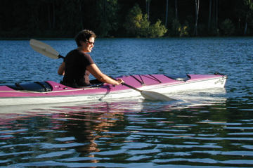
Thursday evening was my first kayaking experience, and it was a blast! T and I went out the inlet, across to the other side of Keyport, across the main channel, and almost as far as Poulsbo — a couple of miles in all. The feeling of this area from the water is much different from that by land. Like many homes situated on water, the “front” is really the water side, not the side facing the road, and there are some beautiful ones around here. We saw several seals and plenty of birds as well. On the way back over the main channel, we could see Mt. Rainier lit up from the setting sun, floating just above the water. Those pictures are on the film camera, but A did get photographic evidence of my adventure with the digital as I was trying to figure out what I was doing.
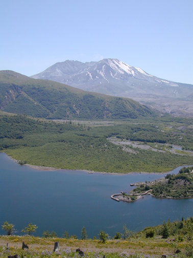
Friday we left early for Portland, where A’s parents live. We stopped on the way at Mount St. Helens. I was telling my hosts that I really don’t remember much about when it happened. I know that it made the news everywhere, but I guess it just didn’t make an impression on me. Seeing it in person from relatively close up really brought home the magnitude and violence of the eruption. I’m used to the slow-erupting shield volcanoes of Hawaii, and this was nothing at all like that.
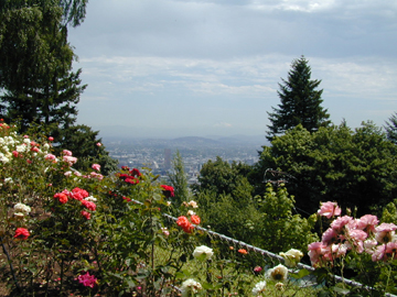
Portland was spectacular. I love that city. Saturday we left Little T with his grandparents and A, T, & I took off to tour the city. We drove through several hip and happening neighborhoods, strolled the grounds of the rose garden and Pittock Mansion, did a little shopping at Powell’s, had lunch at a great little cafe called Cup & Saucer, and visited the Chinese Garden. A’s parents were gracious hosts, putting up with a total stranger for two nights.
This morning we headed out to see the Columbia River Gorge on the way back to Keyport. The river has been tamed by dams, but you can still get the sense of how powerful it is and how forbidding it must have been to the pioneers on the Oregon Trail. Now of course there are highways old and new running alongside the river, making it a snap to see a number of dramatic waterfalls. We stopped at Latourelle Falls, Bridal Veil Falls, and Multnomah Falls, the latter being the most dramatic and the most accessible, thus the most touristy.

Tomorrow morning I leave this place and start heading south for good. I’m aiming for Lincoln City, Oregon, with stops along the way at Astoria, Seaside, and Cannon Beach. Lincoln City itself is not supposed to be all that picturesque, but it does have a concentration of reasonably priced and recognizable hotels.
Posted: July 11th, 2002 | Author: Lori Paximadis | Filed under: cross-country adventure | Comments Off on hiking in Washington
These past few days, much hiking has ensued, leaving me little time and energy for catching all my loyal readers up on the doings, so here’s a recap.
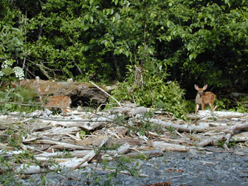
Friday we took a scenic drive all over the Kitsap Peninsula and hiked up to Staircase, which is in the Olympic foothills near Lake Cushman. (Right around 47.5° N and 123.5° W, if you’re following along on your map.) It was a glorious day and a relatively easy hike alongside a swift-moving mountain river. I believe the river is the Skokomish, although I could be wrong. After a mile or so along the trail, beyond the Staircase Rapids for which the hike is named, the river mellows out through a bit of bottomland area, where there were zillions of smooth river rocks

and some really tame deer. Neither these two babies nor their mother were at all concerned that we were nearby.
Beyond this point the trail narrows and climbs into an area called Beaver Burn, the site of a 1985 forest fire. Seventeen years later, you can still see the damage.
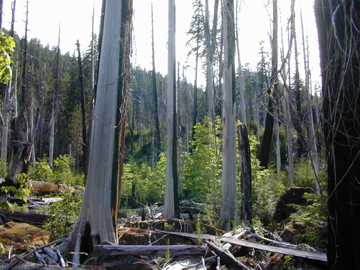
What surprised me most was the debris underfoot. Somehow I had expected the ground to be bare, or at least just normal woodsy ground, rather than the huge jumble of giant logs that it was. This was the edge of the burn, though, so it might have been different farther in. At this point we turned around and headed back.
+-+-+-+-+
Saturday was another perfect weather day, and T & I took the ferry from Bremerton over to Seattle to meet up with his friend G to do an “easy” Cascades hike to Tinkham Peak. In reality, it was in the mountaineering/rockclimbling book as easy, which means it was a few notches above easy on the hiking scale. Part of the hike followed the Pacific Crest National Scenic Trail, which puts it near 47.25° N and 121.5° W on the map, although the none of the lakes we saw on the hike are on the map I have.
We drove to a gate toward the end of a logging road, then walked a hot and dusty mile or so up the abandoned road to the Pacific Crest Trail. We crossed a small but swift stream after throwing a few rocks in for footing, and climbed for a bit more. Rounding the bend at the top of the waterfall above our stream crossing, we came upon snow and Mirror Lake (note to OSU people: not even a little bit of relation), which was still partially frozen — on the 6th of July.

The snow felt great after long, hot uphill trek. We rested a little while, then started across The Slope That Would Defeat Me.
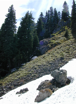
Outside of the right-hand frame of this photo, above the snow, was a jumble of rocks like that seen across the snow. I traversed that with some trepidation, considering the steep slide down the mountain that would result if I fell. I made it along the big boulder in the center of the picture to the bottom of the nearly vertical slope that takes you to the upper right-hand side of the picture, where I got really shaky and uncertain and thus intelligently called the quits. My companions cheerfully escorted me back to the other side of the snow slide before continuing on at my insistence, leaving me with a Thermarest and the bug stuff and G’s shirt, since my Polarfleece was in T’s pack back up on TSTWDM. (I was already well set with a lighter, water, a sandwich, a chocolate bar, and an extra set of car keys, lest you think we’re complete idiots.) I climbed up on a rock and dug my heels into the snow against sliding, and literally cooled my heels until they returned. I freaked out a little bit, having stray thoughts about wildcats and bears, and how much they must love roast beef sandwiches, and from how far away would the scent of food attract them, anyway? Did I really remember the route back across the snow to get back to the trail, should it be necessary? Would an earthquake send me hurtling down the slope with all those loose rocks? After a while I settled down and started to enjoy the quiet and the view.
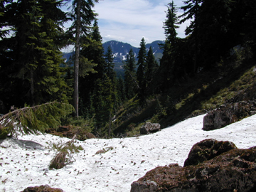
I could hear the roar of the waterfall and stream below, the cracking of the ice on the lake, the occasional fall of snow from the fir trees around me, hundreds of unusual (to me) birds that I never did see, the flurries of flies and mosquitos that wanted to feast on me, DEET aside, and of course the imaginary wanderings of critters larger than me. I dug a little hole in the snow to cool my sandwich and refrim my melted chocolate. The sun was hot and the snow was cold and all was right with the world for a while. I just sat and soaked it all in.
I was glad to hear the approach of my companions, though, about an hour ahead of schedule. Apparently I made a good choice of heel-cooling spots, as the top of the slope was scary and the ridge even scarier — this description from one used to this kind of hiking. After a bit of rest, we headed back down. I felt like I had conquered the mountain (even though I hadn’t), with only a few scratches and some hellacious bug bites (which are still itching four days later, thank you).
Rather than returning on the ferry, we drove around through Tacoma and across the Tacoma Narrows Bridge. Remember that one from high school physics, the bridge that oscillated and eventually broke apart? It looked like just a manini little bridge in those film loops, but let me tell you that the span it crosses is big, and it is awfully high up. The new bridge has a profound curve to it to prevent oscillation, but it’s still freaky to drive over it.
+-+-+-+-+
Sunday was a day of relative rest and back to gray raininess. After a long sleep-in, we took a drive to a neglected state park called Shine, just on the other side of the Hood Canal Bridge. There were blue heron and rocks and shells galore, and only a few other people. I carried my hot tea and walked slowly through the rain, something I haven’t done in a long time.
Monday I dropped off film and we ran errands and did a little shopping. I called to check on the progress of my car, which they said would be ready that afternoon. T insisted on driving me, so we went yesterday afternoon to retrieve it, this time taking the ferry from Bainbridge Island over to Seattle. It feels good to have my car again.
+-+-+-+-+
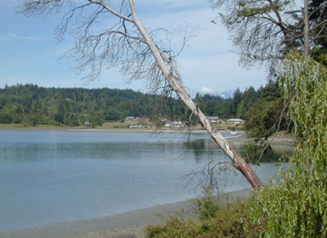
My hosts have been extremely gracious, and have gone above and beyond to make me feel welcome and at home. They are private people, so I don’t talk about them much, but their hospitality has made this trip just glorious so far. I have seen so many things that I wouldn’t have seen on my own, and have eaten so much good food, and have had such a great time just touring around and hanging out and playing with the little one. Their house is comfortable, and has a nice view of the Olympics when it’s clear.
+-+-+-+-+
Today we went antiquing in the morning, and I found a huge old glass cookie jar for a bargain price. The afternoon was a hike to Stavis Bay, which is on the other side of the peninsula between Seabeck and Holly. I picked up some oyster shells there. We got a pizza at Seabeck Pizza on the way back, and man oh man was it good. Not quite Emilio’s, but close.
Tomorrow we’re going to poke around in Poulsbo, a nearby town with little shops and a famous bakery.
Posted: July 8th, 2002 | Author: Lori Paximadis | Filed under: cross-country adventure | Comments Off on tranquility
Two gloriously sunny days sent us out into the wilderness this weekend; to Staircase in the Olympic foothills on Friday and up near Lost Lake in the Cascades yesterday. I’m still recovering from yesterday, which was a decidedly harder hike than Friday’s, so no pictures or details until maybe tomorrow. Both areas were beyond gorgeous, and certainly beyond the adequacy of my words to describe them.
Today we were back to rain and gray, but took a drive across the Hood Canal Bridge to a forgotten state park for a damp walk on a pebbly beach. Two huge pink and purple starfish were washed up on the beach, waiting for the tide to come back in and rescue them. Where were my cameras, you ask? Back at the house, of course.
This past week has been restorative.
Posted: July 1st, 2002 | Author: Lori Paximadis | Filed under: cross-country adventure | Comments Off on O, Canada!
The trip started off a bit less than auspiciously. My original flight was cancelled due to mechanical problems with the plane, something I didn’t find out until I was ready to leave for the airport. They couldn’t help me on the phone, so we headed out to the airport. After some begging and waiting, they were able to book me on an Air Canada flight leaving at 2:30 a.m. The alternative was waiting until the next evening to take a nondirect flight. The upside of that would have been the free roundtrip tickets they were handing out for the inconvenience, but it would have meant delaying the start of my trip and having to say all of those goodbyes all over again. I wasn’t up for it, so opted to wait the seven hours.
The flight was typical with the usual long-distance flight complaints, the kicker being the delay in my luggage coming off the plane, causing me to miss the 11:40 shuttle to Victoria and to have to wait for the 1:40 shuttle. From then on, though, it has been quite nice. The ferry ride over was spectacular as it went through the islands to the north of Victoria, although the 60-some-degree weather made it a cold journey.
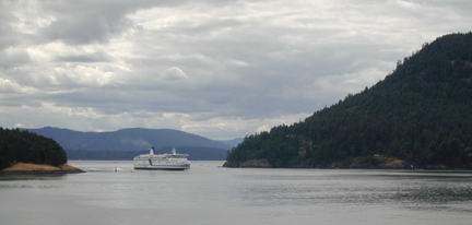
A nice young man from Toronto noticed my all-manual Ricoh camera as I was standing on the bow taking pictures and asked me to take a picture of him and his friend with his all-manual Pentax, since I “look like I know what I’m doing.” They had just finished their cross-country road trip from Toronto to Victoria, and we chatted for a while. I have to remember to ask Tara where they’ve been hiding all these nice Toronto boys…
And oh yes, happy Canada Day! Canada is 135 years old today. It didn’t even occur to me when I planned this trip that I would be in Canada for Canada Day, and I found myself in the midst of Canadian craziness. After checking into the Strathcona and taking a revival shower, I headed out to track down something to eat and experience some of the party in the streets.
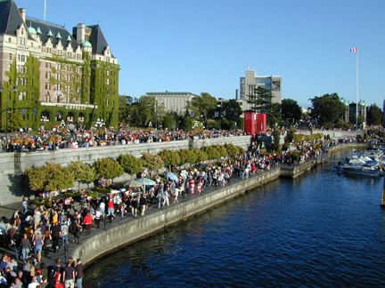
I wandered down to the harbor and up and down a few of the back streets, stopping at a few stages of the Folk Fest, which Victoria is in the midst of. I ended up in a corner pub, which seem to be a dime a dozen here. My fish and chips were good, though, and I tried a peach cider, which was a little sweet but tasty nonetheless. I popped into a few shops and wandered down a few more streets, then decided I was just too cold and tired to wait outside for the fireworks.
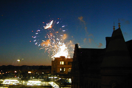
I knew lying down would end up in nap-taking, and that it did. I woke up right before the fireworks started, and just opted to watch them from my room since I have a decent view.
The crazies are still out, parading up and down the streets and shouting “CA-NA-DAAAAAAAA!!!!!!!!!!!!!!!!!!!” but I’m tired enough to sleep through it, so off I go.
